
Thirty-five years ago, the lignite mine of the Matra Power Plant in Bükkábrány was set up right in the middle of a location known as a “cradle of life”. It is where the Csincse Stream flows down from the Bükkalja Foothills to the Great Hungarian Plain, right in the middle of the millennia-old trail where the mountains and plains meet.
“Cradles of life” are locations that possess outstanding environmental conditions for human settlement, regardless of the era. The Herman Ottó Museum of Miskolc has been carrying out excavations in the area affected by the continuous expansion of the mine at Bükkábrány since 2007, resulting in one of the largest excavation zones in Hungary, an area larger than 500,000 square metres. The excavation features various finds and sites from nearly all major archaeological periods from the Neolithic to the Late Middle Ages. Based on an initiative by the Municipality of Bükkábrány, a small exhibition was created using the unprocessed finds from the site, providing a cross-section of the history of the mine and the archaeological excavations carried out there. This document aims to present the aforementioned exhibition, highlight the relationship between the local community and the mine, and reference significant finds from the excavation.
The former bald cypress (Taxodium) forests located at the foot of the Matra and Bükk mountains on the ancient shores of the Pannonian Sea, which used to stretch over the entire Carpathian Basin, have become a rich layer of lignite over the past ten million years. This lignite is currently strip mined at the village of Bükkábrány, Hungary. Mining is carried out in a fan-like shape, with one side constantly expanding while the other side is filled in with leftover strata. This means that the mine is in constant motion, “wandering” along. The areas and archaeological sites that cross the path of this wandering are excavated in advance by museum staff.
The exhibition entitled “The Secrets of the Wandering Mine” was set up at the Miner Memorial House in Bükkábrány, in an area of one hundred square metres in a former Kádár-era village home (Fig. 1). The exhibition is centred around twelve significant elements, which include both discovered finds as well as stories that were deemed to be equally important not only for the local community, visiting tourists and student groups, but also for the archaeologists who have spent thirteen years of their lives at this site.

Fig. 1: The village home housing the exhibition
The area of the excavation site is extraordinarily large – 500,000 square metres is about the same size as one hundred football fields or half the size of Margaret Island in Budapest (Fig. 2) – and includes dozens of sites, finds and features that have been significant in the archaeological research of the Carpathian Basin. The finds selected for the exhibition were chosen to make visitors think about several archaeological topics that we believe could also give them a better understanding of the present-day environment in which we live.

Fig. 2: The excavated area: 100 football fields or half the size of Margaret Island…
In terms of the future of the settlement, the closure of the mine is planned within the next five years. This will be a significant change for the locals who work there. While selecting the finds and stories for the twelve themes of the exhibition, we believed that the chosen topics should also have present day relevance for the people who currently live here. As such, the exhibition includes finds that showcase how the Carpathian Basin was a significant location in terms of both information exchange and innovation throughout various periods – topics that will remain relevant to the village in the present as well.
Organizers of an exhibition always set out with a theme, a core concept that they believe will resonate and stick with the visitor after leaving. Based on the various stories related to the archaeological finds presented, the theme of this exhibition is, “you can view the whole world from Bükkábrány”.
In the case of intensive archaeological sites such as the advancing lignite mine, the duration of an excavation is measured in years instead of weeks or months. The excavations near the edge of the strip mining activities creates a unique wind tunnel. The air carried by the wind is hot and dusty in the summer and very cold in the winter, which wears on the personnel over time. The archaeologists and workers on the site formed special communities by the end of their work. Because of the current structure of archaeological excavation work related to large-scale projects, archaeologists carry out work in the field throughout the entire year, which leaves them with few opportunities to publish the finds and stories they uncover. Unless the structure of preliminary excavations changes from the current methodology established by Hungarian museums over the past 25 years, the archaeologists working in these large areas will be deprived of the opportunity to take care of the finds and process the observed features and stories properly. This will result in large-scale excavations remaining shrouded in secrecy for a very long time.

Fig. 3: „The Secret 12”
The Secret 12
The archaeological exhibition at Bükkábrány is centred around twelve major topics, each showcasing a different period and its characteristics (Fig. 3).
1. Ancient trees in the lignite: Earth science – what provided the framework for local human activity? In 2007, a section of a seven-million-year old grove of bald cypress (Taxodium) consisting of sixteen trees came to light sixty metres beneath the soil. These trees can be viewed at a separate exhibition in the Herman Ottó Museum in Miskolc.
2. Bovine protome: Neolithization – the Carpathian Basin is the key. Using as a starting point the ornamental depiction of a bovine on the wall of a Neolithic vessel – the earliest such depiction from the Carpathian Basin – we present one of the most significant innovations of the era, the domestication of animals.
3. Baden wagon pot: Abstract depiction of a wagon – changes in transportation and communication. During the Late Copper Age, approximately 3500 years BCE, the wheel and the wagon appeared simultaneously in Mesopotamia, the Carpathian Basin, and northern Europe. The invention of the wagon revolutionized transportation and sped up the spread of information, which overall led to more complex networks of relationships spanning larger areas. Cattle, which likely represented the greatest form of wealth during the period, were bred not only for meat, but also for milk and their strength as beasts of burden for pulling wagons and carts. Meanwhile, other livestock was kept for its wool. These innovations in domestication and gastronomy introduced new practices in several areas of everyday life, such as clothing and pottery.
4. Map pot: Middle Bronze Age – Well-recognizable order everywhere. Inspired by the characteristic decorative pattern of a Bronze Age bowl, we discuss the orderliness of this period that was present in all areas of life, then compare it to the settlement pattern of present-day Bükkábrány.
5. Bronze depot: Bronze finds in a group, considered a treasure by modern standards. The reason why these bronze goods were hidden is unknown, however they show that the settlement was more than a mere transportation junction at the time. The contents include two sheathed axes, saw fragments, apparel pin and awl fragments, one intact cloth needle, one large intact ring, ring fragments, and two small molten bronze nuggets.
6. Boar with a bird’s beak An extraordinary find from Bükkábrány. The find is from the Sarmatians, a group whose territory neighboured the Scythians at the Black Sea. Similar finds were excavated from mass burials in the lower Volga region, dated to around the 6th or 5th century BCE. It is made from a deer’s antler and is decorated with the image of a predator (a wolf) on the left side, and a wild boar with a bird-like beak on the right side (Fig. 4).

Fig. 4: The “wild boar with a beak”
7. The first Euro: Celtic coin from Bükkábrány. The Celts often worked as mercenaries for other nations, including the army of the Macedonian King Philip. This is how they were introduced to the concept of money. The “global” currency of the era (global meaning Europe for the most part in this context) was the philippeus, the coin minted by King Philip, which was worth four drachma. The Celts attempted to create counterfeits of it.
8. Sarmatian clothing and jewellery: lunula, fibula: The Sarmatian period is one of the most significant periods of Bükkábrány’s history. The most accurate information on Sarmatian attire is provided by their burial grounds. A total of 263 (!) Sarmatian burials from five separate cemeteries have been excavated at Bükkábrány. Findings from them show that the clothing worn by Sarmatian women was very ornamental, characterized by heavy beaded embroidery. The excavation of the female attire presented here as well as the effort to preserve the hundreds of small beads in their original locations must have been as much of a challenge for the archaeologists today as the creation of the dress was in the past.
9. The Csörsz Trench: Visible from outer space. There is a mysterious network of trenches that runs 1,200 kilometres from the Danube Bend to Mezőkövesd, continues through Bükkábrány towards the east, then takes a turn south at Ároktő and proceeds all the way towards the lower Danube. This trench is so large that it is even visible from outer space. The exact age of the trench cannot be determined, but it is most likely that it was built by Roman military engineers during the 4th century CE (presumably between 322 and 332 CE), as a defensive fortification for the Sarmatians living in the area of the Great Hungarian Plain. The name comes from folklore. Many versions of the tale are known, but the essence of the tale is the same: a King (Knight) Csörsz needs to get to his bride by boat, so he ordered his people to dig a channel large enough for the endeavour. However, his efforts ultimately end in failure.
10. The medieval village of Olaszegyháza: The largest Árpád period village in northeastern Hungary, located near Bükkábrány. The name of this village poses several questions: was it inhabited by an ethnicity other than Hungarians during the Árpád period? Did the village also have a church that is yet to be found?
It can be assumed that the village was settled in by a group of neo-Latin speakers, who introduced new methods of agriculture and viticulture. Written sources first mention Olaszegyháza in 1221. By 1281, records claim that the village had been abandoned (“terra… vacua et habitatoribus destitute”). Based on this information, historians hypothesize that it was destroyed during the Mongol Invasion in the 13th century. Following a survey using metal detectors carried out in the area of the village in 2015, researchers came to the same conclusion based on the spread and characteristics of the metal finds they uncovered. Based on surface finds, it has been presumed that the location of the former houses of the settlement can also be determined. Only following the processing of the finds that came to light during the excavation can it be established whether the hypothesis of the historians and researchers about the settlement’s destruction during the Mongol Invasion is true or not.
11. The battle of Mezőkeresztes: One of the most important locations of Hungarian history. The banks of the Csincse Stream, flowing down from the mountains to the Great Hungarian Plain at Bükkábrány, was one of the most important sites in the Ottoman–Hungarian wars. It was at this location, in October of 1596, where the united Christian armies nearly defeated the army of the Ottoman Empire, but ultimately lost, leading to further devastation in the region. Signs of the battle show up along both banks of the Csincse Stream, including carved stone cannonballs as well as cast lead musket balls.
12. An elusive church on an elusive map: Where to find the medieval church of the village of Ábrány? The location of the medieval village of Olaszegyháza is well-known. But what do we know about the location of the medieval settlement of Ábrány?
Present day Bükkábrány was formed from two medieval villages, Upper and Lower Ábrány. The edge of Lower Ábrány was located for the most part within the area of the present-day lignite mine. While it has already been partially destroyed, the location of its church is well-preserved on a map. The map is located at the National Archives of Sweden, in a collection that contains images and maps of various castles and battles. One of these maps depicts the 1596 battle at Mezőkeresztes. The main points of reference during the battle were the churches of the nearby settlements, including the churches of Mezőkeresztes and Lower Ábrány. By overlaying this map onto a modern one (should a potential excavation be organized in the future), it becomes clear that the former church of Lower Ábrány can be found right in the middle of the present-day cemetery of the village at Kálvária Hill.
Who Are You? Where Do You Come from? Neolithization Has Become a Community Cause
While selecting the titles for the twelve topics of the exhibition, we occasionally chose to use terminology that is mostly known only to archaeologists. Nevertheless, our aim was to aid visitors throughout the experience and always use the contemporary world as a point of reference. During the presentation of the Bronze Age finds, we compare the modern-day settlement structure of Bükkábrány to that of the 4,500-year-old settlement excavated at the edge of the village. However, for the people of Bükkábrány, the most important connection to help understand the past and present was developed in relation to the process of Neolithization. The most significant outcome of the Bükkábrány excavations was the fact that we were able to excavate several Neolithic villages at the edge of the present-day settlement. This not only helped archaeologists to gain a better understanding of the Neolithic period of the Carpathian Basin, but also allowed the locals to learn about their ancestry. One of the four rooms of the exhibition is completely devoted to the theme of “Where do you come from?”, with clay statues from the Neolithic period on display (Fig. 5).

Fig. 5: The room devoted to the Neolithic period
Current archaeological data cannot provide a definitive answer to the origin of the Neolithic populace of the Carpathian Basin, including those in the area of Bükkábrány. It is up for debate whether this population migrated from the south (from the Anatolian and/or the Balkan regions), or if it was comprised of the pre-existing Mesolithic communities that went through a shift in terms of lifestyle. Ultimately, no final answer can be given. It is also unknown whether the main motif in the exhibition, human figures with triangle-shaped heads and flat bodies, were made by the indigenous population of the area or by a migratory group (Fig. 6).
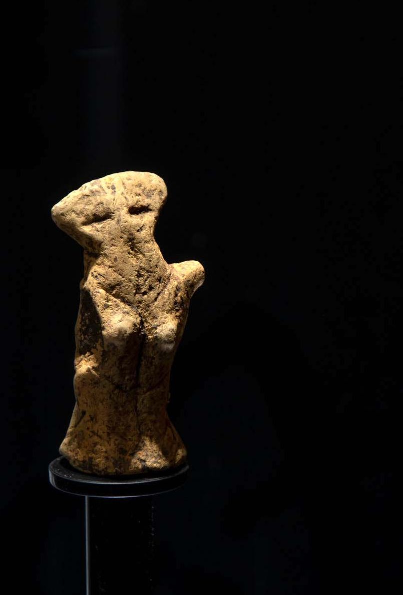
Fig. 6: A human figurine from Bükkábrány
This aforementioned element of the exhibition is augmented by the villagers and their own stories. The present-day inhabitants of Bükkábrány, both young and old, explain who they are and where their families come from. By doing so, they end up becoming the faces of these 7000-year-old clay figures, regardless of whether they are native to the village or newcomers. (Fig. 7). This archaeological topic resonated the most deeply with the people. One kindergarten teacher decided to reimagine these figures and began sewing similarly shaped plush figurines for the children, while another local wrote a storybook about them (Fig. 8). The organizers of the exhibition were also inspired by these ideas, and as a result, the figures of contemporary miners seen on the walls of the Miner Memorial House have triangular heads. In addition, this refurbished Kádár-era village home has simple, blocky furnishings evocative of the videogame Minecraft.

Fig. 7: The stories of locals are also part of the exhibition

Fig. 8: Locals were inspired – they made figurines and a storybook
The Largest
The contemporary history of Bükkábrány is defined by the mine. Forty years ago, everyday life meant working in the fields at the edge of the village. Today, there is a mine pit where those fields were, redefining the landscape. The exhibition tries to emulate the sense of scale of being inside the mine’s ten story tall bucket wheel excavator (the largest of its kind when it was made) via a virtual reality experience.
Exhibition curators: archaeology: Klára P. Fischl, Tamás Pusztai, mining: György Halmai
Exhibition contractor: Á.Tóth és Barátai Produkciós és Reklámügynökség Kft.
The website of the exhibition, available in both English and German: www.bvbt.hu
Recommended literature
Faragó, N., K. Tutkovics, E. & Kalli, A. (2015). Előzetes jelentés Bükkábrány-Bánya, VII. lelőhely pattintott kőeszköz anyagáról. [Preliminary report on the chipped stone assemblage of Bükkábrány-Bánya, VII] A Herman Ottó Múzeum Évkönyve LIV (2015), 25–37.
Herman Ottó Múzeum Régészeti Tár (2018). Árpád-kori ház rekonstrukciója [Reconstruction of an Árpád-age house; video]https://www.youtube.com/watch?v=rTy1PVSAWX4 (Letöltve: 2021.03.25.)
Horváth, A., Gaál, V. & Sydney Nagy, J. (2018). Árpád-kori ház rekonstrukciója Bükkábrány-bánya XV. lh, Olaszegyháza lelőhelyről. Herman Ottó Múzeum Régészeti Tár [Reconstruction of an Árpád-age house from Bükkábrány-lignite mine XV.lh, Olaszegyháza site]. http://regeszet.hermuz.hu/2018/02/05/arpad-kori-haz-rekonstrukcioja-bukkabrany-banya/ (Letöltve: 2021.03.25.)
K. Tutkovics, E. (2015). Szarmata temetkezések a bükkábrányi lignitbánya területén. Bükkábrány-Bánya, XI/A lelőhely szarmata sírjai [Sarmatian burials in the lignite mine of Bükkábrány. Sarmatatian graves at the archaeological site of Bükkábrány-Bánya XI/A]. A Herman Ottó Múzeum Évkönyve 54, 221–274.
K. Tutkovics, E., Kalli, A., Bálint, M. & Bacskai, I. (2015). A megkerült falu. A műszeres leletfelderítés tapasztalatai Bükkábrány-Bánya fejlesztési területén.[The village found. Magnetic survey results at the development area of the site Bükkábrány-Bánya.] In Benkő E., Bondár M. & Kolláth Á. (eds.), Magyarország Régészeti Topográfiája – Múlt-jelen-jövő. A 2015. május 11–13 között, Budapesten rendezett konferencia előadásainak és posztereinek kivonatai (p. 40). Budapest: MTA-BTK Régészeti Intézet.
Kalli, A. & K. Tutkovics, E. (2016). Középső neolitikus és szarmata település Bükkábrány határában (Előzetes jelentés a Bükkábrány, Bánya VII. [Vasúti-dűlő] lelőhely 2011-ben végzett régészeti feltárásairól) [A Middle Neolithic and Sarmatian settlement on the outskirts of Bükkábrány (Preliminary report of the excavations at the Bükkábrány, Bánya VII [Vasúti-dűlő] site in 2011)]. Régészeti Kutatások Magyarországon 2011–2014 (2016), 18–28.
Kalli, A. & K. Tutkovics, E. (2017). Meddő idők. Régészeti kutatások a Csincse-patak völgyében a bükkábrányi lignitbánya területén. Magyar Régészet 6 (1) [2017 tavasz], 1–11.
Kalli, A. (2017). New Late Bronze Age Findings from Borsod-Abaúj-Zemplén County (Northeastern Hungary). In G. Kulcsár & V. Szabó, G. (eds.), State of the Hungarian Bronze Age Research. Proceedings of the conference held between 17th and 18th of December 2014 (pp. 73–82). Budapest: Hungarian Academy of Sciences – Eötvös Loránd University – Prehistoric Society.
Németh, A. (2019). Szkíta farkas – kelta vadkan, két jóbarát? [Scythian wolf – Celtic boar, best friends?] Herman Ottó Múzeum Régészeti Tár. http://regeszet.hermuz.hu/2019/04/17/szkita-farkas-kelta-vadkan-ket-jo-barat/ (Letöltve: 2021.03.25.)
P. Fischl, K., Kienlin, T. L. & Pusztai, T. (2016). Dél-borsodi bronzkori településkutatások. Magyar Régészet 5 (2) [2016 nyár], 1–7.
Selján, É. & Veres, J. (2008). Újabb lelőhelyek az Alföldi Vonaldíszes Kerámia kultúrájának korai időszakából Borsod-Abaúj-Zemplén megyében (Előzetes jelentés) [New Early Alföld linear potter sites in County Borsod-Abaúj-Zemplén (Preliminary report)]. A Herman Ottó Múzeum Évkönyve 47, 5–28.